Heavy to very heavy rainfall likely at isolated places over Coastal, South Interior Karnataka
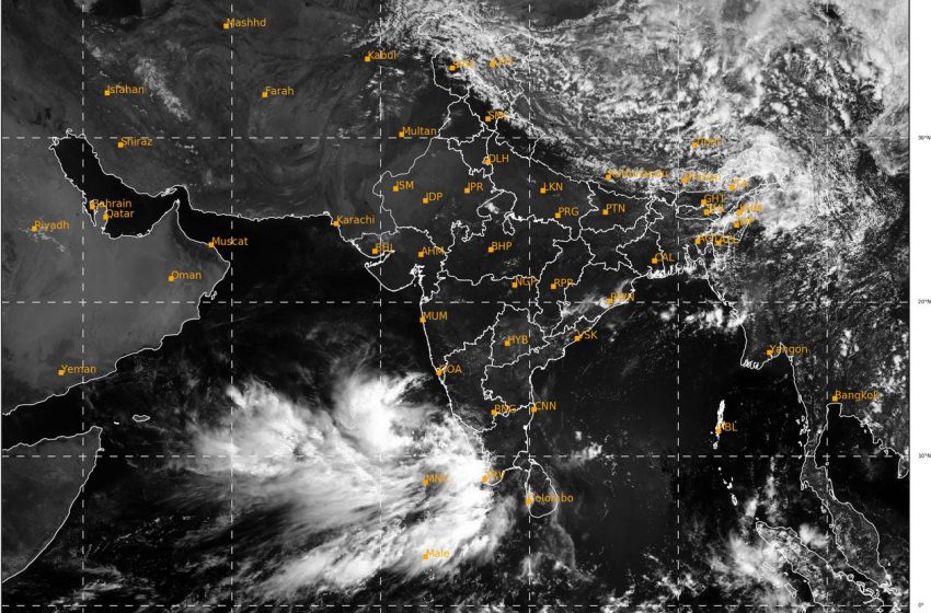
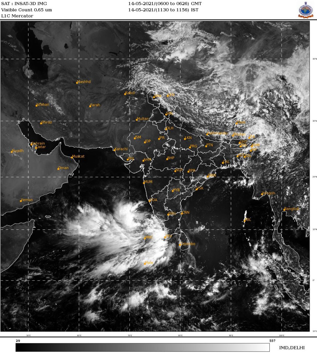
Mangaluru, May 14, 2021: The low pressure area in Arabian Sea is likely to bring heavy to very heavy rainfall at isolated places over Coastal and South Interior Karnataka.
The well marked low pressure area lies over Lakshadweep Area & Adjoining southeast Arabian sea. It is very likely to concentrate into a depression over the same region during next 12 hours and intensify further into a Cyclonic Storm during subsequent 24 hours.
According to IMD it is very likely to intensify further and move north-northwestwards towards Gujarat and adjoining Pakistan coasts. It is likely to reach near Gujarat coast around 18th May evening.
Under its influence, heavy to very heavy rainfall is likely at a few places over Lakshadweep during 13-16 with isolated extremely heavy falls on 13 and 14, heavy to very heavy rainfall is likely at a few places over Kerala during 13 to 16 with extremely heavy falls (less than 20 cm) at isolated places on May 14 and 15 and heavy to very heavy rainfall at a few places likely over Coastal & adjoining Ghat Districts of Karnataka during 14-17 with extremely heavy fall at isolated places on 15.
Weather Warning during next 5 days
14 May (Day 1): Thunderstorm with lightning & gusty wind (speed reaching 40-50 kmph) very likely at isolated places over Gangetic West Bengal; with lightning & gusty wind (speed reaching 30-40 kmph) at isolated places over Punjab and Haryana, Chandigarh & Delhi, Jharkhand, West Bengal & Sikkim, Madhya Maharashtra, Marathwada, Konkan & Goa, Telangana, Coastal Karnataka, Tamil Nadu, Puducherry & Karaikal, Kerala & Mahe and Lakshadweep; with lightning at isolated places over Jammu & Kashmir, Ladakh, Gilgit-Baltistan & Muzaffarabad, Himachal Pradesh, Uttarakhand, Rajasthan, Vidarbha, Chhattisgarh, Arunachal Pradesh, Assam & Meghalaya, Nagaland, Manipur, Mizoram & Tripura, Coastal Andhra Pradesh & Yanam, Rayalaseema and Interior Karnataka.
Heavy to Very Heavy Rainfall very likely at a few places with Extremely Heavy Falls at isolated places over Lakshadweep and Kerala & Mahe; Heavy to Very Heavy Rainfall at isolated places over Coastal & South Interior Karnataka and Tamil Nadu, Puducherry & Karaikal and Heavy rainfall very likely at isolated places over Sub-Himalayan West Bengal & Sikkim.
♦ Squally Weather (wind speed reaching 40-50 kmph gusting to 60kmph) very likely over Southwest and adjoining Southeast Arabian Sea and adjoining equatorial Indian Ocean, Maldives, Comorin and Lakshadweep area and along & off Kerala coast. Sea conditions over southeast Arabian Sea and adjoining Lakshadweep – Maldives area & equatorial Indian Ocean will be rough to very rough. Fishermen are advised not to venture into these areas.
15 May (Day 2): ♦ Thunderstorm with lightning & gusty wind (speed reaching 30-40 kmph) very likely at isolated places over Jharkhand, Sub-Himalayan West Bengal & Sikkim, Gujarat state, Konkan & Goa, Coastal Andhra Pradesh & Yanam, Telangana, Rayalaseema, Karnataka, Tamil Nadu, Puducherry & Karaikal, Kerala & Mahe and Lakshadweep; with lightning at isolated places over Jammu & Kashmir, Ladakh, Gilgit-Baltistan & Muzaffarabad, Vidarbha, Chhattisgarh, Gangetic West Bengal, Assam & Meghalaya, Nagaland, Manipur, Mizoram & Tripura, Konkan & Goa.
♦ Heavy to Very Heavy Rainfall very likely at a few places with Extremely Heavy Falls at isolated places over Coastal & South Interior Karnataka and Kerala & Mahe; Heavy to very heavy rainfall with extremely heavy falls likely at isolated places Tamil Nadu, Puducherry & Karaikal and Lakshadweep and Heavy Rainfall at isolated places over Madhya Maharashtra (ghat areas), Konkan & Goa, Coastal Andhra Pradesh & Yanam, Rayalaseema and North Interior Karnataka.
Squally wind speed very likely 50- 60 kmph gusting to 70 kmph over southeast Arabian Sea and adjoining Lakshadweep – Maldives area and adjoining equatorial Indian Ocean and also along & off Kerala – Karnataka coasts. Squally wind speed reaching 40-50 kmph gusting to 60 kmph likely along & off south Maharashtra & Goa coasts. Squally Weather (wind speed reaching 40-50 kmph gusting to 60kmph) also very likely over Southwest and adjoining Southeast Arabian Sea and adjoining equatorial India Ocean. Sea condition over eastcentral Arabian Sea will be very rough to high. Fishermen are advised not to venture into these areas. Tidal wave Warning:Tidal wave of about 1 meter height above the astronomical tide is very likely to inundate low lying areas of Lakshadweep Islands on 15th & 16th May.
16 May (Day 3): ♦ Thunderstorm with lightning & gusty wind (speed reaching 30-40) likely at isolated places over Gujarat state, Madhya Maharashtra, Marathwada, Rayalaseema, Karnataka, Tamil Nadu, Puducherry & Karaikal, Kerala & Mahe and Lakshadweep; with lightning at isolated places over Vidarbha and Chhattisgarh.
Heavy to very heavy rainfall likely at a few places over Konkan & Goa and South Interior Karnataka; Heavy to Very Heavy Rainfall at isolated places Madhya Maharashtra (ghat areas), Coastal & North Interior Karnataka, Tamil Nadu, Puducherry & Karaikal, Kerala & Mahe and Lakshadweep and Heavy Rainfall at isolated places over Coastal Andhra Pradesh & Yanam and Rayalaseema.
♦ Gale wind speed reaching 60 – 70 kmph gusting to 80 kmph over east-central Arabian Sea and adjoining southeast Arabian Sea and Lakshadweep area. Gale winds speed also likely reaching 60-70 kmph gusting to 80 kmph along & off Kerala – Karnataka coasts Squally wind speed also likely to reach 50-60 kmph gusting to 70 kmph along & off south Maharashtra –Goa coasts on16th May.♦ Squally Weather (wind speed reaching 40-50 kmph gusting to 60kmph) also very likely over Southwest and adjoining Southeast Arabian Sea and adjoining equatorial Indian Ocean. Sea condition over High to very High over northeast Arabian Sea. Fishermen are advised not to venture into these areas.Tidal wave Warning :Tidal wave of about 1 meter height above the astronomical tide is very likely to inundate low lying areas of Lakshadweep Islands on 15th & 16th May.
17 May (Day 4):♦ Thunderstorm with lightning & gusty winds (speed reaching 30-40 kmph) likely at isolated places over Gujarat Region, Telangana, Rayalaseema, Coastal & North Interior Karnataka, Kerala & Mahe and Lakshadweep; with lightning at isolated places over Rajasthan, Madhya Pradesh, Chhattisgarh and Andaman & Nicobar Islands, Coastal Andhra Pradesh & Yanam, South Interior Karnataka and Tamil Nadu, Puducherry & Karaikal.
Heavy to very heavy rainfall likely at a few places over Konkan & Goa; Heavy to very heavy rainfall at isolated places over Madhya Maharashtra (ghat areas), Coastal Karnataka and Kerala & Mahe and Heavy Rainfall at isolated places over Saurashtra & Kutch, South Interior Karnataka and Tamil Nadu, Puducherry & Karaikal.
Squally wind speed reaching 40-50 kmph gusting to 60 kmph likely over northeast Arabian sea and along & off south Gujarat & Daman and Diu coast. Sea condition over very likely to be very rough to High over northeast Arabian sea & off Gujarat coast.
18 May (Day 5): ♦ Thunderstorm with lightning & gusty winds (speed reaching 30-40 kmph) likely at isolated places over Gujarat Region, Telangana, Rayalaseema, Coastal & North Interior Karnataka, Kerala & Mahe and Lakshadweep; with lightning at isolated places over Rajasthan, Madhya Pradesh, Chhattisgarh and Andaman & Nicobar Islands, Coastal Andhra Pradesh & Yanam, South Interior Karnataka and Tamil Nadu, Puducherry & Karaikal.
Heavy to very heavy rainfall likely at a few places over Konkan & Goa, Saurashtra & Kutch and Kerala & Mahe; Heavy to very heavy rainfall at isolated places over Madhya Maharashtra (ghat areas) and Coastal Karnataka and Heavy Rainfall at isolated places over South Interior Karnataka and Tamil Nadu, Puducherry & Karaikal.
Squally wind speed reaching 40-50 kmph gusting to 60 kmph likely over northeast Arabian sea and along & off south Gujarat & Daman and Diu coast. Sea condition over very likely to be very rough to High over northeast Arabian sea & off Gujarat coast.