Authorities Brace For Cyclonic Storm Tauktae
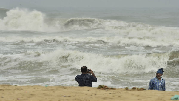
With Cyclonic Storm Tauktae, the first storm of the unusually hyperactive season knocking on the West Coast of India, local authorities along the three coastal districts of Karnataka have gone into overdrive. The storm was formed from a tropical disturbance near the equator in the South China Sea and gradually organized in the Gulf of Thailand, before emerging in the Andaman Sea, where it formed on April 15.
As things stand now, the low-pressure area over Lakshadweep and the adjoining southeast Arabian Sea is now lying as a well marked low pressure area over the same region.the low pressure area over Lakshadweep and adjoining southeast Arabian sea is now lying as a well marked low pressure area over the same region.
The storm, according to Indian India Meteorological Department (IMD) is then likely to intensify further. It will then move north-northwestwards towards Gujarat and adjoining Pakistan coasts and reach near Gujarat coast around May 18 evening. IMD authorities did not rule out the intensification of this cyclone similar to super cyclone Amphan. The authorities say it is difficult to pinpoint what category of intensification the cyclone will reach while noting that conditions are extremely favourable for its rapid intensification.
Under the influence of the cyclonic storm Tauktae, heavy to very heavy rainfall is likely at a few places over Lakshadweep during May 13 to 16 with isolated extremely heavy rain on May 13 and 14; heavy to very heavy rainfall is likely at a few places over Kerala during May 13 to 16 with extremely heavy falls (more than 20 cm) at isolated places on May 14 to 15; heavy to very heavy rainfall at isolated places over Tamil Nadu is very likely on May 14 to 16, with extremely heavy falls at isolated places on May 15.
RELIEF MEASURES CHALKED OUT
Local district administration has already liaised with the Indian Coast Guard who have already initiated actions to shepherd all the fishermen to the coast and not allowing people to go out fishing. Coastal security police are on high alert to ensure people don’t go fishing. Revenue officials have been instructed to alert all people residing in low lying areas and make plans to shift them to safer places.
Relief centres will be opened if needed. Officials will keep a tab on the home isolation cases in village/ urban areas so that if these houses are in low lying areas, they will be shifted at the earliest to Covid Care Centers. This will avoid mixing up patients in case of floods. Inmates of houses which have been identified as prone to landslides will be shifted either to their relatives’ place or cases wherein they don’t have alternative arrangements will be shifted to relief centres
Any ongoing road works which might get flooded will be barricaded. Contractors in those areas will get this done to avoid people falling into pits. Electricity distribution companies will check on power lines/poles to minimise power disruptions. Fire and emergency services and forest department will immediately attend to uprooted trees in urban local body and gram panchayats areas.
COAST GUARD WARNING
Indian Coast Guard ships on routine patrol have relayed weather warnings to the mariners at sea in general and fishing boats, in particular, to take shelter in the nearest port/shore. In addition, Coast Guard has issued an advisory to the fishermen ashore not to venture out at sea. Coast Guard ships at sea and aircraft are reaching out to fishing trawlers, fishing boats and Merchant Mariners relaying them IMD weather warnings on VHF and urging them to return to the shore as soon as possible or take shelter in the nearest port/harbour.
This post has been published in arrangement with Jaideep J Shenoy